Before heading to the main subject... while I was having breakfast (alongside Ullswater) two red squirrels ran at full speed along the top of the stone wall - amazing how something different instantly catches the eye - even though I've seen them before - not having the correct camera/lens at hand, also being in a bag, not switched on etc didn't help so was grateful to have got what I did... sadly many people that visit the Lake District never see these wonderful animals.
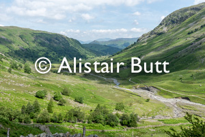
Having moved on and parked at the small village of Seathwaite on what was going to be a hot day. The above view shows the start and end route. The foreground path heads to Stockley Bridge - an old pack horse bridge - do a Google images search for 'stockley bridge seathwaite' will show that in more detail.
Having crossed the bridge my path leads up the steep flanks of Seaththwaite Fell heading up to meet the stone wall about 3/4 of the way up the right hand side. Closer to the top the path is near the top of Taylor Gill Force - and impressive waterfall but better viewed from the path on the other side. I with head around Seathwaite Fell, the main mountain in this view and come back via the valley (Grains Gill) on the left hand side having visited a number of Tarns on the trip.
View from near the top of the waterfall - the far distant mountains are on the other side of Keswick - more of them later
Having gained some height and time spent exploring Synhead Gill (to right) the land leveled out for a bit.
To the left is the lower slopes of Seathwaite Fell, distant view (left) is Scarfell and Lingmell with the lower slopes of Green and Great Gable to the right...
Synhead Tarn comes into view - still following the gill - main path to right
Now above the tarn on what is Syn Head - an important crossing of footpaths...
Looking in the other direction - Lingmell to the left while deep down in the valley is Wasdale Head - one of the walks up Scarfell is from Wasdale Head and comes up this valley and meets the corridor route (plus others at this point) - again see Google images 'corridor route scafell pike' which had images and maps...
More climbing, now between Styhead and Splinkling Tarn with the bulk of Great End coming into view
Moving around Sprinkling Tarn - being very hot the insects were out in force not that it stop some people heading for the water... for many on the walk from Seathwaite to Scarfell, they head around Great End - off to the left and around the right - 4 miles via the crows - a return walk of around 7-9 hours but then you think of Joss Naylor MBE (fell runner and sheep farmer) who did the top to bottom in 45 minutes plus at age 70, he ran 70 Lakeland fell tops, covering more than 50 miles and ascending more than 25,000 feet, in under 21 hours.
Height was about 2000ft at this time, not really that high, and when I think back to when I was young and walked up mountains up to 10000 in South Africa and Lesotho.
Now on the other side of Sprinkling Tarn looking towards the bulk of Green Gable (center) with Green Gable to right with Windy Gap in the middle...
Top of Ruddy Gill - heading back towards Grains Gill but lots of work on the way... In the distance is Derwent Water (plus Keswick) and beyond that the far distant mountains of Skiddaw, Lonscale Fell and Blencathra.
Some interesting gullies in Ruddy Gill backed by Great End.
More than it's far share of interesting little waterfalls on the way down, although on a hot day and after a dry spell not at their best... but then this same valley holds the UK record for the most rain at a single location in a 24 hour period - 314.4mm.
Total time over 9 hours with all the walking up and down gills (streams), walking around tarns etc, along with doing the reference gathering (sketches etc) side before heading to Keswick for food - Fish and Chips again before the long trip home.